
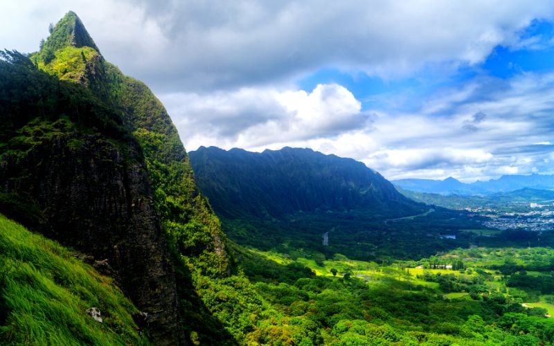
When you think of Hawaii, the first thoughts that come to mind are Sun, Sea, Surf, Cocktails, and maybe a bit of Hula or Tiki Culture. These are all things not to be ignored, but there is another side to Hawaii, very different from the intense commercialization of Hawaii’s Tourism. While on Oahu, large parts of the island have been given over to industry, agriculture, and urbanization, There are still huge swathes of the Island that are left pretty much in their natural state. Over 55% of Oahu’s land s protected by the state and remains largely the way nature intended it…a few nasty invasive species aside.
All this incredible wilderness and natural beauty really beg to be explored, and some of Oahu’s natural areas are seriously remote, rugged, and wild. Fortunately, there is a large network of Trails and hikes all over the island that lets you get away from the madding crowds and out into the wilds of Hawaii. Explore Stunning Mountain Ridge, Hige hidden Waterfalls, Discover lost history, Stomp to the summit of Volvano’s, and find some of the most mind-blowing vistas imaginable. Welcome to the Best Hiking Trails On Oahu Hawaii, where we show you Awesome Hiking trails on Oahu to let you discover the magical side of the Island most visitors do not even know exists!

We have tried to bring you a large selection of varied hikes. There are so many different types of trails on the Island, and so many different types of hikers. We have short but stunning hikes suited to the adventurous tourist, easy and accessible hikes for all abilities, Long and arduous day hikes for those really wanting to get away from the hustle, and even the odd Adrenaline hike that requires extra care and ability.
We even show you the Legal way to hike the infamous, and Illegal, Stairway to Heaven. Whatever type of hike you are looking for, even if you are just seeking a bit of inspiration, you will find your perfect hike here. Be sure to come back after your hike and let us know how it went. But first, we need to take a minute to talk Saftey…Sorry.
Hiking Tips and Safety
You will hear this time and again when visiting islands, so let’s get it out of the way. Hawaii is NOT Disneyland. And what is meant by this is the wild and remote parts of the island are just that. Wild, Remote, and potentially deadly. There is a particular law in Hawaii, that makes it quite different from other parts of the united states. If you venture onto someone’s land and kill or injure yourself, for the most part, that’s on you. In other states, the landowners are at least partially liable.
This leads to lots of land closures and big scary fences, in Hawaii, more places are left open for you to explore, with the knowledge if you fall off a cliff that didn’t have a sign or a fence… tough, you should have looked where you were going.
This means the onus is very much on you to keep yourself safe, and some trails in Oahu can be very dangerous. So here are some tips on keeping safe when hiking in Oahu. But remember, the onus is on YOU. Be aware of your environment and do not overextend yourself. You can always turn back, If in doubt, do not keep pushing on…

Footwear
Many of Oahu’s trails are loose, Muddy, Rocky, uneven, and can be very slippy. The Surface can be bone dry and loose making them treacherous, the same surface when wet can turn into a slick grease that is just as bad. Smooth rocks can be like glass, and everywhere you go are potential fall and trip hazards. The number one way to mitigate these risks is good footwear.
Preferably hiking boots, but anything with good studded souls go bite through to the grippy surfaces beneath will help you stay upright. Running Shoes, sneakers, or trainers are a really bad idea on Oahu’s more rugged trails. Anything with smooth soles is just a recipe for disaster when things get slippy. And we really shouldn’t have to mention that Flip Flops, Crocs or Slippers are not a good idea!
Longer hikes and suitable shoes are even more important, but if you are planning on hiking 6+ miles you probably are already well-versed in hiking and know what shoes will suit you best.
A lot of people even recommend using Mico Spikes on the really Muddy Hikes, this is not something we are familiar with, as Trail Runners, it’s not our specialty. But if you think you might need something like that it’s worth considering.
Fall Risk
Let’s not mince words. People DIE hiking in Oahu every year. While some really dangerous trails have been closed. There are still plenty open, and several are on our list. Hawaii can be dangerous, and while Hiking is not the biggest risk factor for tourists (Car Accidents and drowning top that list) It still makes a real mess of your vacation if you die! And while deaths make the headlines there are countless injures and rescues every week from Tourists who got above their skill level.
Some of the trails we describe have severe drops, likely to lead to instant death, but others are far more sedate, but still have drops and potential falls that could lead to serious injury. Always Hike within your limits and if things feel wrong, turn back.
Sun Saftey
The Sun in Hawaii is strong. Even on cloudy or windy days when the heat does not feel much the UV of the sun is burning down on you. While on the beach or by the pool, if you feel yourself burning you can move out of the sun to mitigate this. Out on an exposed trail, you might not be able to do anything to get out of the way of the sun’s rays.
The key here is to be prepared. Wear High Strength Sun Cream, take a hat that shades the ace, and if possible wear a long-sleeved top. We pretty much live in our Rashies out in Hawaii and this helps protect your whole upper body.
Hiking in the morning and at dusk also helps but this is not an option for longer hikes as you may still get caught in the high sun if the hike goes on too long, or you may end up hiking at night where the fall risks greatly increase, as do you the chances of getting lost!
Water
As we said the sun is Strong, but it’s also HOT. Hawaii is scorching year-round and even in the early morning it rarely falls below 70°f (20°C). Combined with a high humidity level, hiking in Hawaii is HOT. You will sweat, you will dehydrate and you will overheat. There is not much you can do about this other than moderate your effort.
However, Heat Stroke and Dehydration are real risks. So taking water is a 100% necessity. Even on short hikes. On long hikes you may find water is not enough. As you sweat you lose electrolytes (salt) and drinking too much water can actually be fatal. If you are planning on hiking for multiple hours we recommend taking an electrolyte drink with you to supplement the water.
Navigation
Some trails on this list are clearly marked, and others are pretty sketchy. It really is essential to know where you are going. In some places losing the trail could lead you straight off a cliff. Make sure you have a map (preferably paper) and a good sense of where you are going. Ensure you can backtrack easily at all times.
Most of all, DO NOT blindly follow a trail or insist on pushing on because you think “this is the way”. Trails in Hawaii have a habit of drying up and often leading to a sudden drop. Unless you are sure, call it a day and head home.
Communication
Mobile Phone coverage in Oahu can be sketchy especially out in the wilds. So while er always carry our Mobiles, we try not to rely on them. It is always best to tell someone where you are going, even if that is just the Hotel Concierge.
Weather
Down by the coast, there are 2 types of weather. Hot and Dry, or Hot and Raining! Neither really causes any huge problems apart from sunburn or ruing your beach session. However, up in the more remote parts of Oahu, especially the Ridge hikes, the Weather can be very different, and rapidly changing.
A clear dry morning can quickly give way to heavy rain and zero visibility. The sweltering temperature at seal level can plummet as wind and rain sweep the mountains. All that Greenery didn’t come from nowhere, it’s all grown from the copious amounts of rain the mountains ring out of the atmosphere.
Carry extra layers and be extra careful of your navigation in the mountains if there is any cloud in the area. It’s scary how fast visibility can plummet to zero. Also, be wary of nice dry trails that can become super slick after a downpour. Do not get caught on a ridge with slippy paths over exposed drops.
Final Warning
Rember, Hiking is not a safe activity. While some hikes on our list are just tourist trails with very little risk as long as you stay on trial. Others are very different. There are real risks and real people need rescuing, are injured, or die with alarming regularity in Oahu. And trust us they ALL thought it wouldn’t happen to them
Wear appropriate gear, take appropriate precautions, know your limits, and stay WELL within them. If something feels sketchy, it usually is, trust your instinct and turn back.
While Hiking in Hawaii’s remote areas the dangers are 100% real and you only have yourself to rely on to keep you out of danger. There are often no Rails, No Warning Signs, just unprotected drops of hundreds of feet. Be SAFE!!!
Ok, Enough Preaching… Time for the Trails
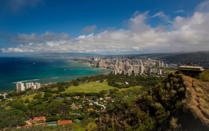
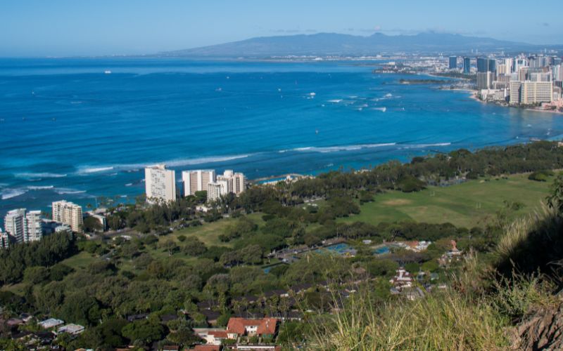
Diamond Head Summit Trail
- Length – 1.8 Miles – Out and Back
- Duration – 45mins – 1:15 Hours
- Map – Google – All Trails
- Difficulty – Moderate
- Elevation – + 425ft
- Notes – Busy – $5 pp + $10 parking – No Shade

One of the most obvious hikes on the island, it should not be ignored simply because it’s popular and a bit touristy. The Hike is easily worth everyone’s time. From the casual tourist to the experienced hiker, the trail offers everything you want from a Hike in Hawaii in a short, compact package. Within an hour you can hike out of the center of a dormant Volcano, up a lush wall of the caldera, to a high province point with the most staggering views up and down the Waikiki Coastline, the Caldera itself, and up to the mountains behind. There are even a few WW2-era installations to boot.
The trail is well made, and you are definitely not going to have any issues in wayfinding. It’s a good lump of elevation, and it’s going to be HOT. But a good lump of effort and the pay-off is basically out of this world. This Hike has more bang-for-buck than almost any other trail we can imagine!
Yes, this is incredibly sanitized and touristy, but it’s just such an incredible payoff. it’s also really conveniently located for those staying in Waikiki.
Advanced Reservation Now Required
Entry to the Park and access to the Hike is $5 per person. There is also a $10 Parking fee for those arriving by car.
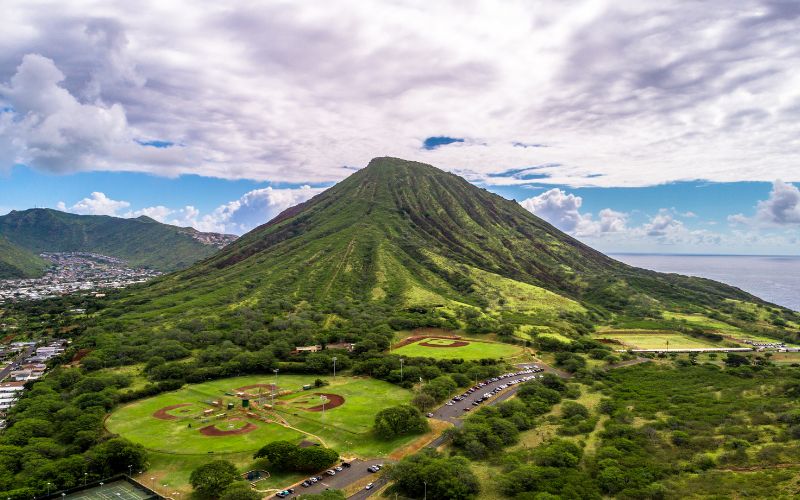
Koko Head Railway Trail
- Length – 1.6 Miles – Out and Back
- Duration – 40 mins-2 Hours (average 1:15)
- Map – Google – All Trails
- Difficulty – Brutal (but short)
- Elevation – + 885ft
- Notes – Short – Sharp – Stunning

There is an easy way to do things and a hard way, and that goes for climbing up Volcanic Calderas. The Koko Head Railway line decides to forgo the easy way, meandering gently up the slopes, and just hits Koko head straight on, right up the steeped flank, from near sea level straight to the summit. This means this trail is a real Lung Busting Leg Burner.
You may wonder why they built a railway track to the summit of a Volcanic crater. The answer was WW2 and the summit was used as a radar base for tracking incoming bombers. Shortly after the war, the advancement of Radar meant it no longer needed to be placed on prominent elevations so the base and railway were abandoned.
That was over 60 years ago and the weather, foot traffic, and the elements have not been kind to the railway. The Sleepers that used to be used as steps to the summit have in large parts fallen away and by the time you get there, more will have rotted and collapsed. So the Staircase that used to exist is no longer in place and at times you will have to take to the mountainside Overall though the trail is definitely still passable, thousands take the hike every day.
It is one heck of a work out though. It starts off steep, gets steeper, and then right at the end becomes damn near vertical! It must have been terrifying riding a tram car up here! We have given a time guide of 30mins to 2 hours, which is obviously a pretty vague range. The KOM on Strava is a staggering 12mins, so even the fittest fastest runners would struggle to do the round trip in 40mins, most people will take 30mins to just climb the stairs, and those needing more stops along the way, take even longer.
Coming down can be even worse, while obviously not as physically demanding the upper slopes are so steep it can be pretty vertigo-inducing as you head down. There will also be hordes of people heading up.
Is it worth it? Oh yes, and for two reasons. This is largely about the physical challenge. It’s a heck of a feat to hike straight up the side of a volcano and you will defiantly feel good about yourself whatever your fitness level. Secondly, well there is the View, it’s seriously mindblowing and worth every ml of sweat!
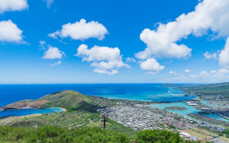
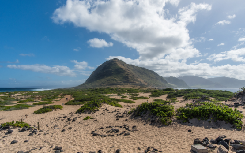
Kaena Point
- Length – 5-6 Miles – Out and Back
- Duration – 2-3 Hours
- Map – Google – All Trails(South) – All Trails(North)
- Difficulty – Moderate
- Elevation – Flat/Undulating
- Notes – Remote – Wild – Quiet

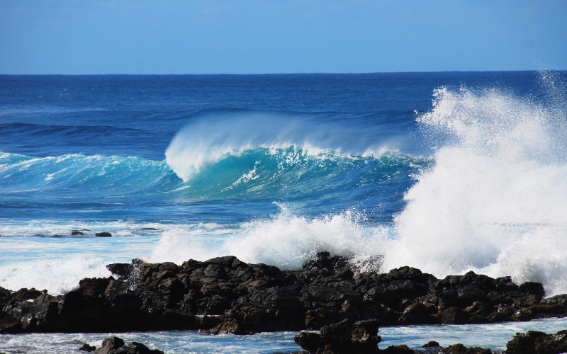
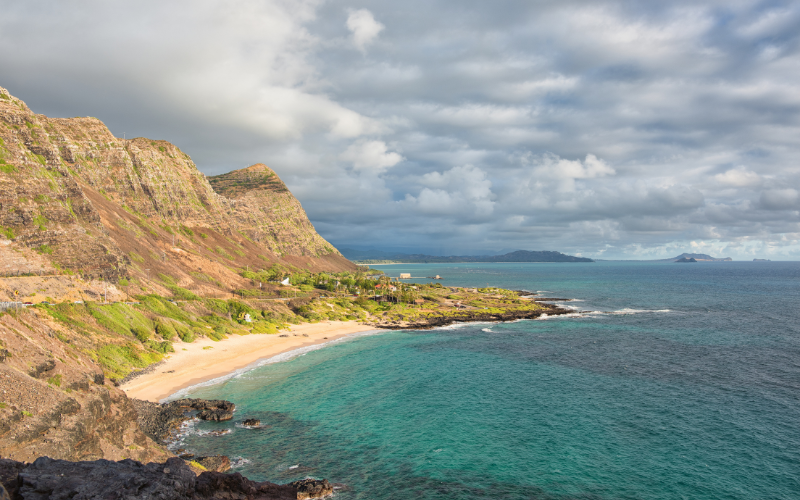
There are two ways to tackle this hike, as we are heading out to the most westerly point of Oahu. The point is remote and wild and offers stunning ocean views and the potential for large shore breakers pounding the rugged and wild coast.
The Waiʻanae mountain range splits this point of the island in two and the only way to get to the point is to hike along the coast on either side of the Range. From the south, you drive in from Waianae until the road runs out and then carry on the trail by foot. The same from the north shore, driving along the coast past Dillingham airfield until you hit the trailhead.
Both routes are flat and on pretty good trials. If it has been raining there can be mud along the trails and stagnant ponds can produce a lot of mosquitos. There is also very little shade so this is perfect for a morning or evening hike.
The rugged coastline offers superb views on either side of the mountains and the whole area feels very wild and remote. Monk Seals, Dolphins, Albatros, Humpback Whales, and Turtles all frequent this part of the coast and thrive as human contact is minimal in this part of the Island.
Whichever side you choose, you can carry on past the point and take in the other coastline, extending the hike to up to 12 miles (although 1-2 miles of the other coast is normally enough). It is possible to turn this into a loop hike, by hiking up to the Kaena Point Space Force Satellite Tracking Station and following the Kuaokala Trail onto the Kealia Trail and back down to the Airfield. But this is getting on for 20 miles and needs a permit to enter the Space Force Base, it’s doable but needs a lot of planning.
While the First two hikes in the list will definitely see you accompanied by hundred of fellow hikers, it’s possible you have the trail to yourselves out here. It’s a wild and remote hike with very few access routes so far few hikers than the popular routes.
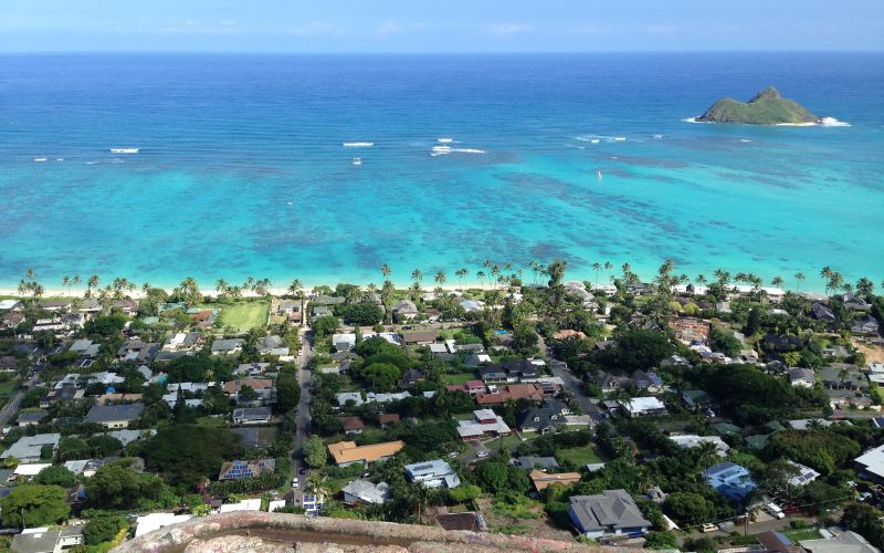
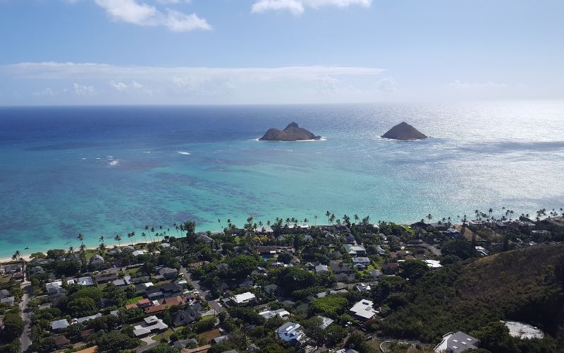
Lanikai Pillbox
- Length – 1.7 Miles Round Trip
- Duration – 45mins -1.5 Hours
- Map – Google – All Trails
- Difficulty – Moderate-Severe
- Elevation – + 626ft
- Notes – Historic – Stunning – Tough

This is a fantastic hike with a whole lot of cool stuff packed into its short duration. Along the short 0.8 mile length you get to visit 3 WW2 Pillboxes. Old lookout and machine gun emplacements were vital for the islands’ defense during those dark years. These emplacements were erected to give sweeping views of the coastline to help spot enemy aircraft and ship movements, these traits make for an excellent scenic vista, and the views from up on the Lanikai cliff is staggering.
Parking is minimal and limited to on-road parking in the surrounding neighborhoods, which is not that welcome. We tend to park at Safeway, which as long as you visit one of the restaurants (A nice Starbucks Frappe post-hike is very welcome) you are technically a customer. We find this better than annoying the locals. The trail starts off as Kamahele St becomes a gated road, you will see a gateway to the right, then heads up.
The trail starts off steep and stays that way for half a mile as you get up onto the ridge. You pass Pillbox one at 0.4 miles and Pillbox 2 at 0.5. The second box is higher and offers far better views, In fact, the best view of the first box is of the second. At the second box, the vista is simply incredible. Panoramic views of the entire Koʻolau Caldera Range. The stunning and verdant Ko’olau mountains, and the shimmering blue waters of the Kailua Bay. It really is a breathtaking scene! All in this is a 1 mile, out-and-back hike with some serious elevation. However, this hike can be extended to take in a 3rd smaller Pillbox.
Honestly after the second Box, the third is a letdown and not worth the extra hike, but the fantastic hike along the ridge is well worth the extra mileage, in fact, we find the initial hike just far too short. Most people miss or ignore the third Pillbox, but we always tag it for completeness.
The trail itself is not too well defined in places and is loose and has some unprotected drops. It’s not the hardest terrain but some care is needed. Wet weather makes for particularly challenging conditions as the top layer turns to mud which is similar to ICE in the way it provides grip!
All in this is a very rewarding hike for the distance and time taken. You can easily hike up to the second box in 25mins and take in one of the best views in Oahu.
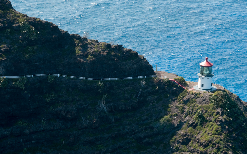
Makapu’u Lighthouse Trail
- Length – 2.5 Miles – Out and Back
- Duration – 1-1.5 Hours
- Map – Google – All Trails
- Difficulty – Easy
- Elevation – + 505ft
- Notes – Accesable – Wild – Stunning

This is a nice and easy hike on a paved path out to the Makapu’u lighthouse. Here you will find one of the best viewpoints on the island looking out and up the windward coastline of the island.
The first half of the trail is a little dull with so-so views and light gradients, but once you take the corner, back out on the other side of the headland the views really open up. First with great views back over Koko Head and then as you look out over the Kawai Cahnnel and potentially catch a glimpse of Molokai in the distance on clear days. During Whale Season you can see whales surfacing in the channel.
As you carry on there is a side detour down to the Makapu’u Tide Pools, but this is a real scramble and quite dangerous on a loose rock face, not advisable at all unless you know what you are doing. Continue up the man path and you will hit the main lookout. There is a side path down to the actual lighthouse, but you get better views from the lookout.
Finally, there is another poorly marked path that takes you up even higher for more views and a couple of old Pillboxes.
This is a fantastic hike for those looking for stunning views but wanting easy and accessible paths. It will not disappoint anyone as the views on offer are really stunning, but it has such good accessibility almost everyone can enjoy this hike.
After the Hike, you could extend it down to Alan Davis Beach, via the Kawai Shoreline trail and cool off in the ocean, or head to Makapu’u Beach Park, for more immediate ocean access.
One word of warning, this area is well known for car break-ins. do not leave valuables in your car here!
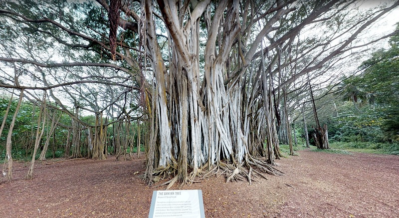
Turtle Bay PillBox
- Length – 2.4 Miles Round Trip
- Duration – 45min-1:15 Hour
- Map – Google – All Trails
- Difficulty – Easy
- Elevation – Flat
- Notes – Easy – Historic – Resort

The north shore is not that well-served for trails. There is a lot of private land and not as many trial options. We wanted to mention this excellent little trail found at the Turtle Bay Resort. it is not particularly challenging, but it has some great features and is pretty accessible.
As you head out from the resort and towards the Stables you follow the coast around to the headland at the end of Ō’owopāla Beach. Here you will find the old ww2 pillbox keeping watch.
Heading away from the Headland you will find a fantastic example of a Banyan Tree, slowly taking over the forest. You can then head down to Honokawela Beach which had good snorkeling or back to the resort where a cocktail will be waiting.
Wiliwilinui Ridge Trail
- Length – 4.8 Miles Round Trip
- Duration – 5-6 Hours
- Map – Google – All Trails
- Difficulty – Severe
- Elevation – + 1700ft
- Notes – Limited Parking available – Gated Community with Guard – Stunning Ridge Hike

Ok, this was a tough choice. We wanted to add a ridge trail to the list, but there are quite a few amazing ridge hikes. So many we could have just had the entire list as Ridge hikes. But we wanted more diverse choices so we have stuck to a single Ridge hike. And we chose Wiliwilinui as it’s arguably the best, and not because it’s called Wili Wili…we are not that childish (yes we are!)
Seriously, this really is one of the best of the bunch, we will add a few options below, but this one has it all. It’s not too severe, not too long, yet still gets you right up to the rim of the Ko’olau Crater rim with staggering views over the inward coast. You also get some really nice vista’s back toward Honolulu.
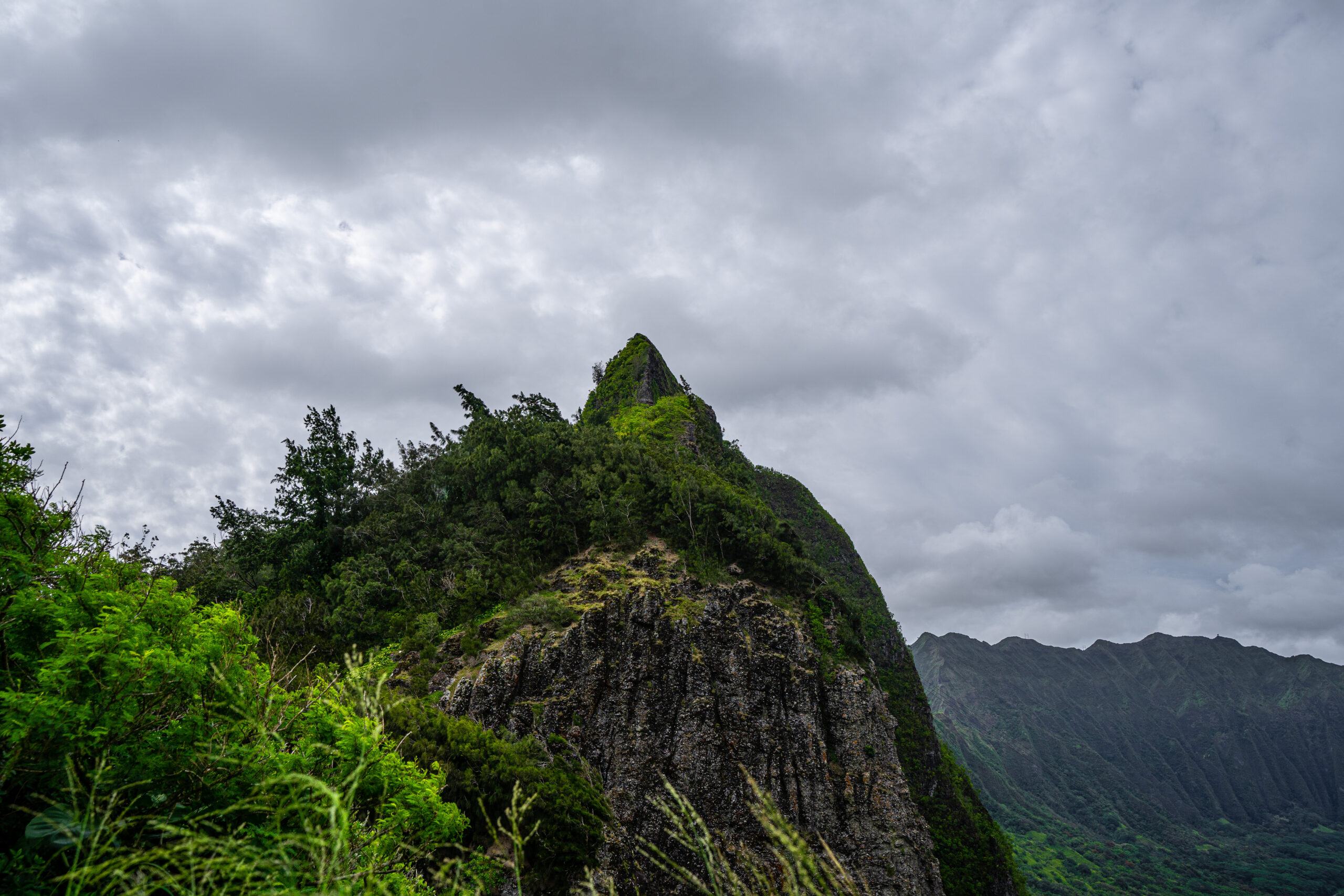
For those that do not know the Ko’olau Mountain Range is not actually a mountain range at all, but the remnant of a callosal volcanic crater. The North-Eastern portion slipped away into the ocean around a million years ago, and almost certainly caused cataclysmic Tsumani’s all around the pacific rim. The years passed and erosion took its toll, making the inside edge extremely steep, but the outer edge more gentle and covered with jungle. Rivers carved deep valleys into the Crater and separating these are rows of ridgelines. Most of these ridges have trails on them that work their way gradually to the edge of the rim, where you are treated with a near vertical drop and epic sweeping vistas beyond.
The Wiliwilinui Ridge is a great option as the trail starts pretty high up the ridge, meaning less distance to hike and less gradient to ascend. However, it’s still pretty poky. The trial is loose and slippy underfoot and can be quite treacherous when wet. As you follow the ridgeline up you get fantastic views back over the south coast and Diamond Head. There are some nice wooded sections and some more exposed drops.
Eventually, you get to a radio Station and looking back here you get amazing views of Honolulu. From here it is just a short push to the Summit and a feast for the eyes over the Windward Coast. There is a vague loose and sketchy trail that runs along the rim, but this is best avoided unless you are highly experienced.

The big issue with the trail is the access. The trailhead is on private property and inside a gated community. However, hiking is tolerated and the Guard at the Gate will issue you a Parking Permit. We have even seen Ubers being allowed up to drop hikers. There are strict limits though and once the parking passes are handed out, no more will be allowed until others leave. So while this is our pick of the Ridge Hikes, it pays to have a backup. This situation could always change as well.
- Kuliouou Ridge Trial – 4.7 Miles – 1700 ft
- Hawaii Loa Ridge Trail – 4.5 Miles – 1600ft – Hawaii Residents
- Mau’umae Trail (Pu’u Lanipo Trail) – 6.7 Miles – 2700ft
- Mount Olympus Awaawaloa via Wa’ahila Ridge Trail – 5.9 Miles – 2100ft
- Lanihuli via Kapalama Trail – 7.4 Miles – 2900ft
- Aiea Ridge Trail – 8.9 Miles – 2800ft
- Manana Ridge Trail to Ko’olau Summit – 9.8 Miles 2700ft
Manoa Falls Trail

- Length – 1.7 Miles Round Trip
- Duration – 45mins – 1.2 Hours
- Map – Google – All Trails
- Difficulty – Moderate
- Elevation – + 600ft
- Notes – Film Sites – Dense Jungle – Unimaginable Greenery!
This moderate hike, up through some seriously dense jungle will have you thinking you have wandered into Jurassic Park, and the Films Locations scouts thought this too, and subsequently filmed some scenes from the franchise in this location. Most notably the scene where zak and Gray Leap from a waterfall to avoid the Ondominous Rex in Jurrasic World, at least that is what most sites and guides will tell you, however, the actual falls are on Kuaui near Ho’opi’i Falls on private property, however, scenes from the film were apparently shot here. The location has also been featured in Lost, Hunger Games Catching Fire, and Hawaii Five-O, so it’s a pretty famous site, not quite Kualoa level, but pretty famous.
Apart from being famous, it is also an incredibly beautiful hike. There is quite a lump of elevation up to the falls but the trail is well-made and easy to hike, for the most part. it can get a bit muddy and rough up near the top, especially in poor weather.
The main highlight of the trail is the incredibly dense jungle. There is so much green, it really is hard to imagine. This is Rain forest how you imagine it, incredibly dense lush, and exotic. The start of the trial is open and every inch of ground and tree is covered in greenery. As you hike up the falls the canopy really closes in and you are encased in dense jungle.
Once at the falls, you can relax a little, it’s all downhill from here. The falls are 150ft high and only have a moderate flow rate, sometimes a mere trickle, but they are still impressive. The hike u is very hot and strenuous, but taking a dip here is a bad idea. Not only is it illegal and officers will fine anyone caught in the pool, but it’s also pretty dangerous with any debris flowing over the falls becoming a dangerous projectile by the time it finds your skull!
Overall the hike is very pretty and not too strenuous. It is nice and convenient for anyone staying in Waikiki and a great way to spend a morning.


Ko’oloa Summit Trail (Pali Puka)/ Old Road
- Length – 0.7 Miles – Out and Back
- Duration – 30mins – 1 Hour
- Map – Google – All Trails
- Difficulty – Brutal
- Elevation – + 485ft
- Notes – Dangerous – Seasonal Closures – Hair Raising

WARNING – This is a really sketchy hike with some serious and exposed drops. Get it wrong up here and you will probably be bypassing the Hospital! This hike requires you to negotiate huge, unprotected drops on loose dirt. Only for the highly experienced.
One of the most incredible roads on the Island is the iconic Pali Highway. The Pali highway climbs over 1200ft to the top of the Ko’olau mountains and back down the other side providing a nice shortcut between Honolulu and Kailua and the windward Coast. It’s a stunning drive and one everyone visiting the island should hunt out. At the top is a Parking lot, and viewpoint offering stunning views out over the Winward coast. There is also Access to a few trails.
This is where you pick up the Ko’oloa Summit Trail. A really short but seriously challenging hike/scramble up to the summit of Ko’oloa and Pali Puka (Cliff Hole). Some of the gradients on this hair-raising scramble are over 45° and it’s loose and slippy with huge plunging drops. At points, the trail is less than a couple of feet wide, and hundreds of feet of thin air beneath.
Only attempt it in good conditions and if you are not sure turn back. This is a seriously dangerous little trail. But the views from the top are spectacular. The is a small hole in the cliff face that offers itself up as a perfect frame for the stunning windward coast.
If this Hairaising trial is a little much for you there is a second hike up here. The Old Road is the original Pali Highway. A much smaller and windier tarmac ribbon that still winds its way down the hillside. It is often closed due to weather and Rockfall but it’s a really interesting hike if you find it open.
Moanalua/Kamananui Valley Trail (Haiku Stairs/Stairway to Heaven)
- Length – 10 Miles Out and Back
- Duration – 5-8 Hours
- Map – Google – All Trails
- Difficulty – Brutal
- Elevation – + 3000ft
- Notes – Legal – Tough – Beautiful

There are some corners of the internet where the mere mention of the Haiku Stairs, also known as the Stairway To Heaven will lead to vitriolic abuse and even banning. And with good reason. The Hike up the Haiku Stairs is Illegal. It’s illegal due to State Law, but it’s also illegal due to the Trespassing needed to get to it. They tried asking people not to Hike the Stairs, but the entitled generations didn’t listen, so they started enforcing it with heavy fines, they still didn’t listen and the enforcement officers kept busy stopping and fining those unwilling to treat the islands with respect.
It’s also a pretty dangerous hike and not one we would recommend. So why are we recommending it, well we are NOT. Let us be clear DO NOT HIKE THE HAIKU STAIRS. And we mean this. This is not an indemnity statement where we tell you not to do something, <wink-wink> and then tell you exactly how to do it, thereby encouraging you to. We think Haiku Stairs Hikers are morons, and we totally condemn anyone breaking the law, trespassing on private property, or just generally annoying the peaceful Kāne’ohe community…So why is it on the list? Because there is a legal route to hike to the summit.
The problem is it’s not an easy hike. But it’s doable, legal, and you get to the exact same place the Stairs lead you, the U.S. Naval Radio Station Haiku. You have the same stunning views and even get to look down the route the law-breakers are hiking. Safe in the knowledge you are a better person than them, and won’t be getting a $1000 fine when you get back down!
The hike is around 5 miles each way and has some pretty tasty elevation changes as you scramble up muddy, loose, and poorly marked trails. Eventually, you will top out on the Moanalua Ridge and can follow this, with jaw-dropping views right to the Naval Station with views out over Kāne’ohe Bay.
It is one of the best hikes on the island with an amazing payoff, but clouds can completely ruin the hike. The trial really isn’t the easiest to follow and it’s tough going and very sketchy underfoot, along with being a very physical hike in terms of the gradient. It’s not an easy route or a shortcut to the stairs, but it’s not like the stairs are a quick and easy route either. Unless you are a very advanced and experienced mountain hiker, avoid this one.


Have You Say
What are your favorite Hikes in Oahu? Let us know in the comments, along with your experiences of hiking any on our list. Did you have a good Hike on one of our hikes, or maybe you think we oversold it? Maybe you know a great hike, and want us to add it to our list, just let us know in the comments. You might know an updated staus or closure of a trail, again we would love to hear from you. And as always any questions just fire away.
